
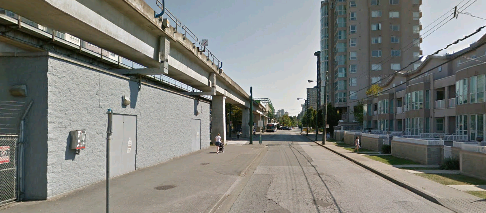
Walking near Joyce Station, Vancouver (Google Image 2012)
Skytrain is being used as the preferred technology for transit in our region. Yet, as this Google view shows, significant issues in urban design present today when we add density within easy walking distance of elevated transit. The challenge we face is combining transit planning with community planning. Typically, this is done under the rubric of an urban design plan.
The most obvious flaw in the photo is the view available to the new homes on the left—or the lack of it. As shown three or four storey residences are compromised when Skytrain is pushed through the heart of a neighbourhood. The same result will obtain all along the elevated track of the Expo Line’s 19 mile (30.5 km) path. The quality of view achieved in our homes affects our sense experience, which in turn conditions our mental well-being. And, how about the noise pollution from trains whirling by at short distances from our windows and doors at all hours of the day, and in rapid succession or ‘tight headways’ during peak hours?
Blighting the urbanism is not just a problem for the Expo Line, it results wherever trains-in-the-sky cross urban land including Vancouver, Chicago and Paris.
TOD (Transit Oriented Development) was supposed to provide high-quality, high-density, human-scale, affordable neighbourhoods within easy walking distance of transit stations. The point was to lower automobile ownership by half, lower automobile use by more than that, and build affordable communities with a palpable sense of place. The problem at Joyce Station, and most other transit hubs in Metro Vancouver, is with defining how high ‘high-density’ should go. Since the time of the Greeks and the Romans this quantity has been known: 3.5 stories in northern cities.
The origins of TOD can be traced back to a week-long charrette hosted by the University of Washington, Seattle. The results were published in 1990 in a small book entitled Pedestrian Pockets.
Peter Calthorpe’s website describes Pedestrian Pockets this way:
The Pedestrian Pocket [is] “a simple cluster of housing, retail space and offices within a quarter-mile walking radius of a transit system,” [It] answers the rapid privatization, depersonalization and fragmentation of suburbia with a model that relies upon mass transit, higher density development and quality public space.
Searching for a name back in those days, attending the 2001 Port Townsend Forum, I settled on the Pedestrian Shed to describe that urban footprint with a 5-minute walking radius. I soon found confirmation for that nomenclature reading neighborhood plans for cities in Australia. Now the term is in widespread.
However, in our metro area TOD has come to mean “Towers and Skytrain”—another term that I coined describing the Mal-appropriation of the urbanist TOD by Vancouver area planners based on their miscalculations of what ‘high density’ means in humanist urbanism. This flaw is exposed finally by studying the quote above and comparing it to the featured photo at the top of the post—and all the other photos in this post. The Skytrain-and-Towers urbanism is about as far from the original proposed scheme as anyone should care to go.
Notice the low quality of the urban realm in the photo. Imagine yourself as one of those pedestrians! This is not a deliberate Jeff Wall photographic representation. This is a random Google car photo taken in 2012. The woman on the left is gazing across at the mother pushing the baby stroller on the other side of the street. The caption could well read, “We Gotta Get Out of this Place!”
One more person is visible in the background. All three are walking in an environment without human scale. There is nowhere to go in sight; and no attractive public realm to traverse on the way. The telephone and power lines on the left are as great a psychological barrier to the sky, as the concrete elevated transit guideway on the right. Notice that the municipality has seen fit to plant not a single street tree! Some planning.
The local transportation authority, Translink, may share some of the responsibility. I must remember to ask the next Translink official I meet whether there is a set-back requirement restricting the planting of trees near the elevated guideway. The answer is probably ‘yes’. The outmoded, driver-less 1980s technology cannot operate in snow without putting a driver on board. And of course, Translink cannot provide enough drivers available when it snows. It is quite possible that falling leaves, or an errant branch, would freeze the entire system!
The front door yards on the left of the picture are closed-off from the street with concrete block walls that appear to be as high as the pedestrian (say 5 feet). While tall garden walls may be appropriate on the rear side of some properties, the desired effect on the front is to put “eyes on the street”. This can only be achieved when fronting residential door yards retain a high level of transparency. Of course, in order to make this desirable the quality of the fronting street must be far different than what was built here.
A final concern is affordability. Our region finds itself in a property price bubble that has put owning a home out of reach of most young families, singles and seniors (classified in census counts as median household incomes). Combining planning with transit implementation in TOD plans should provide the means for accessing cheap land further away from the Central Business District. Distance from the job centre should yield affordability, with fast and convenient transit easing the penalty of living on the periphery. But the formula is not working; something has broken down. Transit is being used to export tower-and-podium urbanism instead from (communist) Hong Kong. Prices all along the corridor and at station areas on the regional perimeter are sky-high. As the price per square foot rises in the tower, it brings up land prices on the nearby parcels. One after the other, skytrain stations spike the price in what were once suburban lands on the peripheral areas of the regional city.
Thus, property prices are made to soar region-wide by the Mal-apropriation of planning tools designed to return exactly the opposite results. Affordability fails to materialize on both TOD lots within easy walking distance of transit stations, and housing lots everywhere else. Real Estate profits go up and up; yet the quality of the resulting urbanism is increasingly lower and lower. Defaulting to the preferred method of assembling land—building condo towers far in excess necessary density, and reaping sky-high profits from naked land speculation—contributes as little as possible to the neighbourhood. Skyrocketing prices notwithstanding, the photo is rife with evidence of an all-out effort to lower costs: Cheap buildings, low-quality neighbourhood design, and stripped-down investment in public realm speak to the naked ambition of maximizing profits for the municipality and developer alike. This alignment of the interests of industry and government may not be ‘fascist’ in nature, yet they appear to be heading in that direction.
Of course, the ‘savings’ are not being passed on to the consumer. As municipalities inherit the responsibility of maintaining this jacked-up level of infrastructure and service, local governments are finding it hard to balance budgets. Land assembly and land-price-lift seem to be combining to keep prices—not just profits—soaring. Are taxes next?
In conclusion—as the photo below amply demonstrates—putting density up against transit lines is not necessary. We can build hi-density without hi-rise by observing the principles of a human-scale urbanism over a pedestrian shed, and then a group of pedestrian sheds, centred around a 12-minute walking radius around fast and efficient transit. Only then will the resulting in neighbourhoods present with hi-levels of social functioning.
Care must be taken to design a public realm that is supportive of social mixing, not the “No Man’s and Woman’s and Children’s Lands” we see above.
In addition, a new paradigm must be embraced where the neighbourhood as a whole is designed (not just ‘planned’). Decisions about the station area cannot be left to the whim of market forces. Local governments and design professionals have a critical role to play, in addition to a mandated democratic duty. Finally, the choice of building product must be made with the purpose of delivering affordable housing for the taxpayer. This race to the bottom—maximizing profits in the private sector, lifting land prices, and maximizing profits in the public sector or city hall—even as we contemplate bankruptcy of local governments blindly chasing after the ‘profits’ of the Towers-and-Skytrain paradigm must come to a full stop.
The result of massive levels of public investment in transit should be affordable housing, livable streets and walkable neighbourhoods. Not this stuff.


Joyce Station Quartier Footprint (dotted line)
The Quartier
The quote from Pedestrian Pockets cites “within a five minute walk of the transit system” as a critical element in TOD design. I have called this footprint the pedestrian shed; the New Urbanism in the United States identifies it as the site for TOD (transit oriented development); and Leon Krier refers to the quartier (urban quarter). In all cases what is associated with this spatially defined footprint of urban land is the delivery of human-scale urbanism, not Skytrain-and-Towers. This puts some distance between ‘good’ urbanism and one of the most elemental failings of Modern Planning. Namely, its inability to established what it meant by a “neighbourhood”. Or to stick to it, once the two Clarences—Perry and Stein—returned to the Roman castrum and the Renaissance town to prescribe human scale—as found in the 5-minute walking distance, and low-rise density—as the critical data in ‘good’ urbanism.
Overlaid on the site aerial photo one soon realizes that the quartier footprint for Joyce Station is more than ample to achieve high-densities within easy walking distance of the station and without having to build giga-scale towers.
The Walk to Transit
Of course, the transit planning literature is even more assertive suggesting that folks might walk five, ten and even fifteen minutes to transit. The corresponding growth in density (measured as units per acre) or population (measured as 2.2 persons per unit per acre) becomes geometric rather than linear. The resulting population from enlarging the radius of the transportation catchment will not be 2x and 3x greater as the table below shows.

Table showing Populations supported at three walk to transit distances.
The results of the table assume an average population density of 80 units per acre (unit size = 800 sq. ft.). This density can be achieved building either 40-foot high walk-up apartments or 3.5 storey fee-simple row houses. However, while some sites in the neighborhood can build out at this extreme high-end of the human-scale urbanism, it would be a mistake to use it as the ‘average density’ achieved throughout the neighbourhood.
A fully built-out pedestrian shed should not exceed 5,000 people. And a group of six pedestrian sheds centred hierarchically around an original quartier should not exceed 35,000 population. The 199,131 shown in the table above is clearly out-of-bounds for Vancouver’s west coast vernacular.
Now, Millennium and Expo Lines share stations, so we have to be careful not to count twice. However, the total number of transit station sites build in Vancouver are as follows:
- Expo 20 stations
- Millennium 13 (stations not shared)
- Canada 15 stations
The total 48 stations can be home to 1.7 million people living within a 15 minute walking distance of fast and effective transit. That doubles the existing population, presenting a build out that may serve us for over 70 years if the population continues growing at its current pace of 1% per annum. We don’t need the towers. The high end of the Human Scale Typologies found in the local vernacular allow us to house 1 million-plus living within station area quartiers.
In conclusion, we offer the following principles:
- Avoid projecting catchment areas that “sprawl” beyond the bounds of the human scale urbanism—it’s just not necessary.
- Focus attention in designing the pedestrian shed or urban quartier surrounding the transit station as clusters of affordable houses, livable streets and walkable neighborhoods.
- Finally, replace the Skytrain technology with 0-GHG trains riding either on the surface of the street or underground.
Reverse View of featured image at the top of the post (Google Images 2012)
Verso (looking in the rear view mirror)
Experts will disagree. In my view there is no advantage to putting up towers and guideways. Two wrongs don’t make a right. This part of the Expo line was built on the old BC Electric R.O.W. That should provide a clue.
The beset transportation choices are compatible with ‘good’ urbanism. This include: subway, modern tram (LRT/streetcar), BRT (B-Line trolleys with both lane and signal priority) and 0-GHG private cars. Commuter service on the main trunk railways (West Coast Express) also have a role to play.
We can see in the photo at the top of the post, and in the views that follow it, just how much damage the Skytrain wreaks on the urban fabric.
We can build much better urbanism than that.

Joyce-Collingwood is one of the few areas along the Expo Line in the City of Vancouver that has actually seen a change in land use in response to “rapid transit”. The area was formerly zoned industrial and it was only because of the developer’s pressure that it changed. He persuaded the council of the day to relax their parking standards – in return for an increased contribution towards the community – in this case a new Community Centre.
The route chosen for the SkyTrain was the former BC Hydro/BC Electric right of way. And the proximity of the houses to those tracks predates the construction of the elevated guideway (in this location in transition to a cut). So the point of view of the image does not really reflect what was planned or changed by the coming of the SkyTrain.
At the next stations along the Expo line towards downtown – 29th Avenue and Nanaimo – no change in land use or density was tolerated by the community. What’s up there? NIMBYism.
[This comment copied over from my own blog]
I wrote this post after I came across a statement that the Joyce station area was now one of the highest density neighbourhoods in the city. So I got on Google and had a look. What I was looking for was the tower areas (they are there too). However—this stretch with guideway fronting houses and three forsaken pedestrians walking as if in white-out conditions—seemed to be the most poignant.
I don’t agree with NIMBYism, Stephen, unless we’re going to change the meaning of Not-In-My-Back-Yard to mean “No Bad Planning In-My-Back-Yard”. At which point I would laud the neighbourhood for sending the plans packing since I have a pretty good idea as to how bad the proposals would have been. The same problem confronts us today.
We tend to forget (at all the right times) just how much in the know plain folks really are. I have every confidence that fellow Vancouverites would have welcomed with roaring approval a competent TOD proposal in any station area. Sadly, I have come to accept that competent urban planning has not originated from any of our local city halls from 1980 to the present—dating back to the time when I first started studies in city building.
Examples of poor quality pedestrial realm can be found in every city, including Paris, Zurich or any other major city. I am not familiar enough with Joyce to comment on the particular photograph but you will not that at the random time that Google took the photos there are 3 pedestrians in the picture. That suggests that they are origins and destinations nearby that are worth walking too.l
Rico, you bring up a good point. The photo is pointed away from Joyce Skytrain (use this search term on Google Maps to view the area). The likely trip generator is the station itself. However, there are a number of local serving establishments that will draw people as well.
I have added an aerial view of the site at the bottom of the post that shows the location and direction of the street-level photo; the station area; the towers; and the general disruption of the urban fabric.
My points are two:
(1) In our region TOD has come to mean ‘Towers and Skytrain’. That is not what TOD was designed to do. Among the unwanted results from ‘Towers and Skytrain’ we count: housing priced out of reach of the very people that were supposed to use it; unnecessary height and density with attendant problems for the resulting quality of neighbourhood feel and character; and unwanted adjacencies to the elevated transit guideway.
(2) The quality of the planning is well below what we find in Paris, Zurich or any major city practicing human-scale urbanism. Note the single family residential well within the 5-minute walking radius suggested by TOD. The aerial makes clear my contention that we can build ‘Towers on Their Side’, achieve a human-scale public realm, and spread the development potential more equitably among a greater number and mix of developers and builders. That last opportunity will help safeguard our political process from the corrupting tendencies of power.
The result we see is just poor process on the part of the people we elect and appoint to carry out these massive investments of the public purse. Results like these have led me to see tower-and-podium outside the downtown as ‘high-density sprawl’. Our efforts at implementing transit are sub-standard or worse.
I’m reading Speck’s Walkable City at the moment and he makes this point very succinctly. “Local density + complete neighborhood.” No digital version available so I can’t quote at length sadly.
Neil, you put me in the mind of thinking that if a literature review were to be done prior to a Council decision on issues of built form and density within walking distance of transit stations, then the issue would be mute. Human scale urbanism would win hands down every time. Good film at DOXA this year just with that title “Human Scale”:
http://www.doxafestival.ca/festival/films/humanscale
You also use that bad-boy word of planning “neighbourhood”. So, as preamble to a response, I posted a diagram showing the pedestrian shed or urban quartier for Joyce Skytrain. Needless to say there are single family residential lots by the hundreds that remain untouched by the transit implementation in their back yard. Who loses? We do. Our senior levels of government invest our wealth but we don’t see all the positives from it.
Finally I added a table to the post showing build out numbers in units and people for pedestrian sheds with a footprint radius of 5, 10 and 15 minute walking distance. This goes to your point of “local density” and mine of “how local is local?” The difference in footprint from a 5 minute walking radius to 15 minutes is almost ten-fold!
The larger issue that we are both pointing to is that unless we design at the scale of the neighbourhood or quartier, we are not going to get the TOD right.
The second issue is that this kind of urban design must happen at the same time that the transportation decisions are being made. The last two lines to build in our region (Canada & Evergreen) were planned and either built or nearly built before any meaningful discussion took place about the right kind of urban form for the station area catchment.
Lewis, you are right in some extend:
(1) It is a shame that Vanness street didn’t get tree and kept its aerial utility here (East of Joyce is much better)
(2) The skytrain viaduct is dominating the space.
(3) and the view from the 3 storeys townhouse is not good.
for other aspect, the electrical substation…etc…other have answered…
The reason for (1) clearly lie at the feet of CityHall: they should have required that from the 3 storey house developer (which also built a tower beside)
The reason for (2) and (3) is that the 3 storey building is the wrong building form.
Turn your camera 180degree, facing East, and the picture is much better…Joyce is also inviting, and on the ground is busy with grocery store, eateries…Have you noticed the building form?
Much better isn’it?
* On Vanness, 6+ storeys building should be a minimum, to balance the mass of the viaduct. It is like that it is done in Paris, and it is also like that it is done in RIchmond N3 rd: which starts to look pretty good (around Westminster Hwy).
*The Joyce Collingwood neighborhood centre is in fact at Joyce#Kingsway: it has been historically like that (school there), and nowadays Kingsway is still the main shopping arteries for the neighborhood.
…but the skytrain station is a Joyce#Vanness (former interurban), the challenge is to link those 2 magnets, by upgrading Joyce.(actually lined up by derelict buildings), to a “Bd standard”.
Also, may be, rather than pounding every bad thing on the skytrain feet, you could be more helpful at providing critics of new development like the WallAtCentralPark at Vanness#Boundary…just saying 😉
At the end: on building form in General, I guess you will like this street:

…since it promotes many concept you advocates for, and I myself like it too (Do you know where it is?) …It is ~23m wide (~70ft) but how high are the building lining it?
Greetings to you and to your cat, Voony. Good to hear from you. Here is a list of elements in urbanism from your reply:
Street trees
Aerial vs Underground utilities
Skytrain viaduct dominating urban space
Building form (or type: 3-storey walk-up; row house; tower)
Neighbourhood centre
Shopping street
Transit station
This list is taken from studying the photo you attached (filename suggests Kunming, China; 16th largest city; Pop. 6 million):
Mediterranean-like climate (chinese characters in the signage?)
Heart of a neighbourhood (guess)
Street trees (London Plain?)
Aspect ratio 1 : 2
Perimeter block massing
Pedestrianized street
Continuous ground plan (barrier free)
Pedestrian lighting
High-end retail (?)
‘Good’ urbanism awaits architects, engineers, landscape architects, community leaders, politicians, and just-plain-folks being able to talk to each other about values like the ones in the lists. Elements representing significant investments by private and public sectors. And, it awaits a serious discussion about how we are going to curb the runaway cost of housing where LRT was supposed to make a difference, and the towers are evermore implicated with making the situation worse rather than better.
You make very good points:
Turn your camera 180degree, facing East, and the picture is much better…
Done. I’ve posted the view. The pedestrian on the left (now on the right) can be seen entering her residence. The mom with the stroller is still visible… heading to the station.
What I can’t see is where this is better? The first four storeys of residential on the tower still have the same view problems as the row house neighbours. Now we can see another problem in the public realm. Add to the lack of trees casting shade the problem of towers shadowing the street.
On Vanness, 6+ storeys building should be a minimum, to balance the mass of the viaduct
On GoogleEarth I measure the streetwall-to-streetwall distance on Vanness Ave (BC Parkway) as 102-feet. But… there is LRT in the middle! Principles of human scale, adapted to our latitude, suggest a Street Aspect Ratio of 1 : 3. Thus, 33-foot streetwall on a 102-foot R.O.W. However, the elevated railway down the middle spells the end of the humanist project.
(1) No elevated tracks in urban fabric; and
(2) Building heights restricted to 1 : 3 proportion to the fronting street.
The history of elevated trains in places like Paris and Greenwich Village teach us that the elevated guideway has to come down—sooner or later. In addition, setting the building height should be done in relation to a known quantity (i.e. the width of the fronting R.O.W.), rather than to “correct” for elevated transit.
*The Joyce Collingwood neighborhood centre is in fact at Joyce#Kingsway
Voony, Watch Out! The French Urban Police are looking for you!! A neighbourhood centre is never a street crossing… intersections are simply points on a grid with higher than average vehicular collisions that present as barriers to pedestrian movement.
It was the French that put a name to the neighbourhood centre… the place (Borrowing from the Italian “piazza”; for the Spanish the “plaza”).
I call it The Donut Principle. We know what kind of pastry it is because it has a hole in the middle. Likewise, we know that we are in the neighbourhood centre when we step into an open space, an urban room, a square, place, or piazza.
Kingsway could be a Great Street… but not until the problem of high traffic volume is sorted out. I drove to Kingsway & Joyce twice in the last two days. Nothing has improved since I completed a preliminary study for the Collingwood BIA twenty years ago.
The exception proves the rule. Near La Villette, Paris, the Haussmannian cross at Rue Perdonnet and Rue Louis Blanc is an exquisite piece of urbanism. The sense of place seemed to get stronger with every step as I walked from the edge to the centre—an intersection in this case! Of course La Villette is still blighted by one of the last remaining elevated railways in Paris. The place will get a real boost when it is finally torn down.
Paris teaches something else. The great avenue of the Rive Gauche Boulevard Saint-Germain also suffers from too high a volume of traffic. Yet, Paris is served by one of the best metros in the world, the RER commuter lines, and something like 4 LRTs. Thus, the conceit that we will reduce traffic volume with investments in infrastructure needs to be carefully considered.
the challenge is to link those 2 magnets [station & Kingsway & Joyce
Agreed. The question is… at what scale should we plan the link? At the storefront scale we add another set of eateries and nothing much changes. At the project scale we assemble land and build another tower(s)-and-podium and the results are all negative (soaring house prices, shadowed streets and traffic congestion). It is only when we go to the scale of the neighbourhood as a whole that we reach the point this post is making:
Coordinated decisions in transportation and community planning can only result from planning at the urban scale.
How do we link those two magnets at the urban scale? Easy—we build a human-scale TOD in the middle… Why? Because that is the best process to follow if we wish to see a new community emerging.
….rather than pounding every bad thing on the skytrain feet, you could be more helpful at providing critics of new development…
Is there room for expressing an alternative vision of change in professional circles? Or, should we just toe the line? As I suggested in my reply to Stephen Rees bad planning must be met with NIMBYism from the community. We can add here: and resistance from professionals.
Of course, it all depends on where we are in the historical continuum. Is this the apex of Modernism? Or the sunset?
Given that our discussion here has been based on facts that people can measure and experience for themselves—except perhaps the experience of a human-scale TOD for which one may have to travel as far as Rio Vista, California—maybe we can turn it over to the people themselves to decide.
Dare we present two options for discussion? Or is community consultation to proceed by decree, by a practice where the goose is always cooked before it is presented to the tax payers?