
JERICHO LANDS NEAR UBC
.
1. Human Scale Urbanism
- Build Neighbourhoods… (not “downtowns” or “regional town centers” or skytrain hubs like Joyce Station, Brentwood and Metrotown).
- In neighborhoods where full build out has been achieved use Incremental Intensification and retrofitting as the Engine of Change .
- Reassess the need to Double local populations in Vancouver and elsewhere. Grow new small towns on the periphery of the region instead.
- Build modern tram instead of skytrain.

70TH AVENUE NEAR OAK STREET
.
2. Rebuild the Neighbourhood Cores
- Retrofit automobile-driven suburbia with human-scale, walking places
- Add new destinations @ easy walking distance
- Practice historic preservation
- Build people places
- Add tram nodes
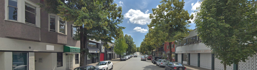
COMMERCIAL NEAR 22ND AVENUE
.
3. Make Walkable Districts
- Build the hierarchies of Place: neighbourhood, district, street and square.
- Zone districts by building type: bungalow, row house, apartment.
- Integrate shopping & work place
.

BROADWAY NEAR CITY HALL
.
4. Revitalize Arterials as Livable Streets
- Improve transit by adding B-Lines & tram
- Pinch car commuter trips
- Green sink adding continuous rows of trees
- Widen the sidewalks to support higher levels of social functioning
.

WEST BOULEVARD NEAR 46TH AVENUE
.
5. Return Affordability
- Working families own their own houses
- Affordable rental = mortgage helper suites
- Build ground-oriented units with front doors on the street, door yards; rear yards; and roof-top decks
- Greet neighbours recycling waste lane-side
.

NANAIMO STREET NEAR GRANDVIEW HIGHWAY
.
A MENU OF CHOICES
These principles can function as a ‘menu of choices’ adopted by local governments for city-wide use, then applied on a neighborhood by neighborhood basis in consultation with local residents.
Local community groups meeting with their elected representatives can incorporate the ‘Principles for ‘Good’ Neighbourhood Urbanism’ in their presentations.
Each principle can inflect in response to local conditions creating ‘the meaning of place’.
This process unfolds over time. Thus, a simple instruction set like the one provided here can serve as a checklist in the future ensuring that neighborhood projects stay laser-focused on their primary objective of making the meaning of place.
PHOTOS: BY GOOGLE STREET VIEW… NOT A TOWER IN SIGHT.

1-3. that land is worth more as farmland or biodiverse unpopulated areas than more unnecessary human sprawl
Thank you for you comment Richard. I’ve often wondered about exactly that issue. How is it so? What metric—in your view—makes the 25% of the GVRDs ‘urban footprint’ more valuable as farmland or bododiverse unpopulated area? I’ve responded already how I see S-P-R-A-W-L as ‘bad’ urbanism that can be corrected by applying the principles behind ‘good’ urbanism. These include concepts of greenbelts and farmland.
However, as I note in the Revitalization of the Land Commission and the Reform of our Fourth Level of Government (https://wp.me/p1yj4U-1zw) there was an obvious expedient used in designating what is today ALR land. Peripheral areas in the 1970s, that were experiencing little demand for urbanization, places like: Pitt Meadows, Maple Ridge, District of Langley, Delta, were the sites where the majority of this land that “is worth more as farmland or biodiverse unpopulated area” was located. The core areas barely have any open or agricultural land reserved at all.
GVRD holds 1.3% of the total ALR in BC, yet it represents 0.3% of the land mass in British Columbia. That’s 433% more ALR contribution than a proportional share of the total. The problem with the “worth” that is being identified is that it appears to be measured in terms of “real estate value” rather than biodiversity or agricultural production. Much of what is today in the GVRD (and elsewhere) is not agricultural level grade. It may be, as you suggest, “bio diverse” (or not).
We just don’t know because the designation took place more or less willy nilly in the earl 1970s when we lacked tools such as GPS to conduct a detailed scientific analysis.
I also want to your attention to your attention Part 7: The Economics Behind a New Regional Strategy. I discuss there the obvious fact that ‘too large a land grab for the ALR’ has led to the 1200% inflation in house value for Canadians here in the Greater Vancouver Regional District. This, it would appear, is the result of nothing more than what is identified in the closing sentence of the piece as: ‘bad’ planning.
Your views on these points would be of interest to the readers here.
I agree that ALR land hasn’t been properly determined or managed, but there is an undeniable value in having active local farms and untouched nature.
Considering the loss of biodiversity across the globe, human activity that wipes out wide swaths of habitable land for animals should be avoided when possible. The activities of animals does more for us than many realize and we need to learn to cooperate with them. Established cities aren’t going to disappear, so the least we can do is keep our footprint reasonable instead of just spreading further every time the local population grows